Property Record
651 Stiles Rd Sw, Cartersville, GA 30120
NEARBY LISTINGS FOR SALE OR LEASE
-
-
No Photo
-
-
-
-
-
View all Cartersville listings for sale on LoopNet.com
Property Detail
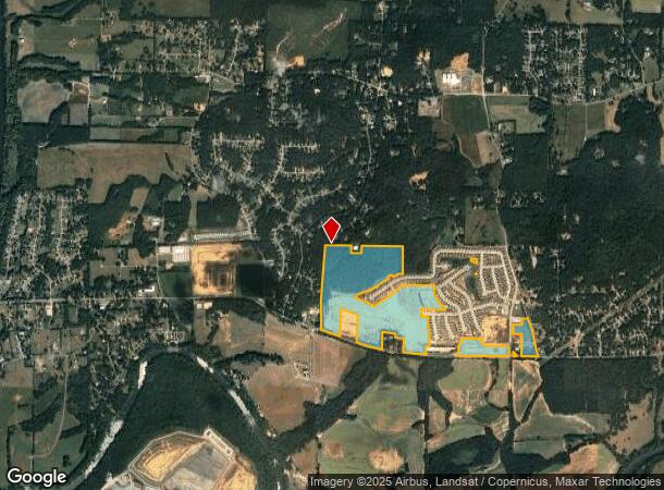
651 Stiles Rd Sw
Atlanta-Sandy Springs-Roswell, GA
LL 644-647, 650-653 D 4
0051-0645-001
Bartow
Agriculturalland
Georgia
X
644-647
13015C0245H
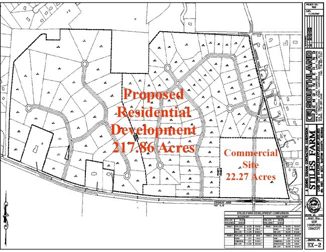
138.13 AC
2024
Bartow County
2024
Atlanta
960902
DEMOGRAPHICS near 651 Stiles Rd Sw
1 Mile
3 Mile
5 Mile
2024 Total Population
1,615
11,064
32,971
2029 Population
1,769
12,072
36,095
Pop Growth 2024-2029
+ 9.54%
+ 9.11%
+ 9.47%
Average Age
39
39
39
2024 Total Households
576
3,897
12,018
HH Growth 2024-2029
+ 9.38%
+ 8.93%
+ 9.27%
Median Household Inc
$81,451
$87,411
$78,893
Avg Household Size
2.80
2.80
2.70
2024 Avg HH Vehicles
2.00
3.00
2.00
Median Home Value
$214,718
$215,552
$237,318
Median Year Built
1992
1991
1991
Nearby Places
Map Layers
Map Styles
 Street
 Aerial
- Restaurants
- Banks
- Shops
- Fitness
- Groceries
Nearby Properties
Address
Land Use
TOTAL SIZE
Lot Size
Zoning
Address
Land Use
TOTAL SIZE
Lot Size
Zoning
94,726 SF
34.82 AC
Address
Land Use
TOTAL SIZE
Lot Size
Zoning
132,946 SF
26.63 AC
Address
Land Use
TOTAL SIZE
Lot Size
Zoning
58,757 SF
22.63 AC
A1
Address
Land Use
TOTAL SIZE
Lot Size
Zoning
128.74 AC
A1
Address
Land Use
TOTAL SIZE
Lot Size
Zoning
40,000 SF
18.15 AC
Address
Land Use
TOTAL SIZE
Lot Size
Zoning
242,214 SF
14.71 AC
IN
Address
Land Use
TOTAL SIZE
Lot Size
Zoning
147,500 SF
14.60 AC
IN
Address
Land Use
TOTAL SIZE
Lot Size
Zoning
98,691 SF
12.08 AC
Address
Land Use
TOTAL SIZE
Lot Size
Zoning
85 AC
INDUSTRIAL
Address
Land Use
TOTAL SIZE
Lot Size
Zoning
58,074 SF
20.28 AC
I1
Address
Land Use
TOTAL SIZE
Lot Size
Zoning
30,000 SF
53.17 AC
IN
Address
Land Use
TOTAL SIZE
Lot Size
Zoning
91,612 SF
5.44 AC
IN
Address
Land Use
TOTAL SIZE
Lot Size
Zoning
23.28 AC
AGRICULTUR
Address
Land Use
TOTAL SIZE
Lot Size
Zoning
1,063 AC
A1
Address
Land Use
TOTAL SIZE
Lot Size
Zoning
57.89 AC
IN
Address
Land Use
TOTAL SIZE
Lot Size
Zoning
1,400 SF
37.84 AC
Address
Land Use
TOTAL SIZE
Lot Size
Zoning
76,500 SF
Address
Land Use
TOTAL SIZE
Lot Size
Zoning
14,925 SF
4.28 AC
Address
Land Use
TOTAL SIZE
Lot Size
Zoning
13,500 SF
55.40 AC
I2
Address
Land Use
TOTAL SIZE
Lot Size
Zoning
19,440 SF
15 AC
IN
Address
Land Use
TOTAL SIZE
Lot Size
Zoning
21,446 SF
14.87 AC
Address
Land Use
TOTAL SIZE
Lot Size
Zoning
25,480 SF
Address
Land Use
TOTAL SIZE
Lot Size
Zoning
22,184 SF
10 AC
IN
Address
Land Use
TOTAL SIZE
Lot Size
Zoning
38,023 SF
9.73 AC
Address
Land Use
TOTAL SIZE
Lot Size
Zoning
51.82 AC
I1
Address
Land Use
TOTAL SIZE
Lot Size
Zoning
15,600 SF
4.25 AC
C1
Address
Land Use
TOTAL SIZE
Lot Size
Zoning
28,204 SF
5 AC
IN
Address
Land Use
TOTAL SIZE
Lot Size
Zoning
26,900 SF
8 AC
Address
Land Use
TOTAL SIZE
Lot Size
Zoning
228.37 AC
A1
Address
Land Use
TOTAL SIZE
Lot Size
Zoning
184 AC
A1
The World's #1 Commercial Real Estate Marketplace
Connect with us
© 2025 CoStar Group
The information above has been obtained from sources believed reliable. While we do not doubt its accuracy we have not verified it and make no guarantee, warranty or representation about it. It is your responsibility to independently confirm its accuracy and completeness. Any projections, opinions, assumptions, or estimates used are for example only and do not represent the current or future performance of the property. The value of this transaction to you depends on tax and other factors which should be evaluated by your tax, financial, and legal advisors. You and your advisors should conduct a careful, independent investigation of the property to determine to your satisfaction the suitability of the property for your needs.